Jordan Valley, Oregon | |
|---|---|
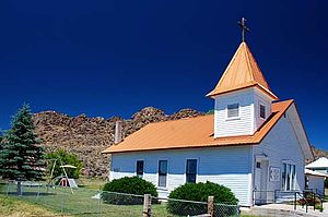
 The Jordan Valley Methodist Church | |
| Motto: "Heart of the Owyhees" | |
 Location in Oregon | |
| Coordinates: 42°58′35″N 117°3′19″W / 42.97639°N 117.05528°W | |
| Country | United States |
| State | Oregon |
| County | Malheur |
| Incorporated | 1911 |
| Government | |
| • Mayor | Marie Kershner |
| Area | |
| • Total | 2.08 sq mi (5.39 km2) |
| • Land | 2.08 sq mi (5.39 km2) |
| • Water | 0.00 sq mi (0.00 km2) |
| Elevation | 4,385 ft (1,337 m) |
| Population | |
| • Total | 130 |
| • Density | 62.50/sq mi (24.13/km2) |
| Time zone | UTC-7 (Mountain) |
| • Summer (DST) | UTC-6 (Mountain) |
| ZIP code | 97910 |
| Area code(s) | 458 and 541 |
| FIPS code | 41-37850[3] |
| GNIS feature ID | 1122534[4] |
| Website | www.cityofjordanvalley.com |
Jordan Valley is a city in Malheur County, Oregon, United States. It is part of the Ontario, OR–ID Micropolitan Statistical Area. The city lies along Jordan Creek, a tributary of the Owyhee River; the creek is named for a 19th-century prospector, Michael M. Jordan.[5] The population was 181 at the 2010 census.
- ^ "ArcGIS REST Services Directory". United States Census Bureau. Retrieved October 12, 2022.
- ^ Cite error: The named reference
USCensusDecennial2020CenPopScriptOnlywas invoked but never defined (see the help page). - ^ Cite error: The named reference
wwwcensusgovwas invoked but never defined (see the help page). - ^ "US Board on Geographic Names". United States Geological Survey. October 25, 2007. Retrieved January 31, 2008.
- ^ McArthur, Lewis A.; Lewis L. McArthur (2003) [1928]. Oregon Geographic Names (7th ed.). Portland, Oregon: Oregon Historical Society Press. pp. 518–19. ISBN 0-87595-277-1.