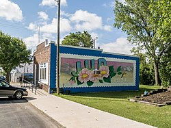
Jud | |
|---|---|
 Post office in Jud | |
 Location of Jud, North Dakota | |
| Coordinates: 46°31′30″N 98°53′53″W / 46.52500°N 98.89806°W | |
| Country | United States |
| State | North Dakota |
| County | LaMoure |
| Founded | 1904 |
| Area | |
| • Total | 0.24 sq mi (0.63 km2) |
| • Land | 0.24 sq mi (0.63 km2) |
| • Water | 0.00 sq mi (0.00 km2) |
| Elevation | 1,739 ft (530 m) |
| Population | |
| • Total | 65 |
| • Estimate (2022)[4] | 64 |
| • Density | 267.49/sq mi (103.14/km2) |
| Time zone | UTC–6 (Central (CST)) |
| • Summer (DST) | UTC–5 (CDT) |
| ZIP Code | 58454 |
| Area code | 701 |
| FIPS code | 38-41180 |
| GNIS feature ID | 1033647[2] |
Jud is a rural city in LaMoure County, North Dakota, United States. The population was 65 at the 2020 census.[3] Jud was founded in 1904 and named for county settler Judson LaMoure.[5] It is located along unpaved 61st Street SE, 9 miles (14 km) west of U.S. Route 281 and 25 miles (40 km) south of Interstate 94 in the midst of settled farmland and open plains.
- ^ "2020 U.S. Gazetteer Files". United States Census Bureau. Retrieved July 24, 2022.
- ^ a b U.S. Geological Survey Geographic Names Information System: Jud, North Dakota
- ^ a b "Explore Census Data". United States Census Bureau. Retrieved January 16, 2024.
- ^ Cite error: The named reference
USCensusEst2022was invoked but never defined (see the help page). - ^ Wick, Douglas A. "Jud (Lamoure County)". North Dakota Place Names. Retrieved May 4, 2011.