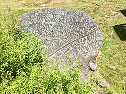
Judaculla Rock | |
 Judaculla Rock, August 2018 | |
| Location | 552 Judaculla Rock Rd., Cullowhee, North Carolina |
|---|---|
| Coordinates | 35°18′02″N 83°06′34″W / 35.30056°N 83.10944°W |
| NRHP reference No. | 13000116[1] |
| Added to NRHP | March 27, 2013 |
Judaculla Rock is a curvilinear-shaped outcrop of soapstone known for its ancient carvings and petroglyphs. The archaeological site is located on a 0.85-acre rectangular-shaped property, now owned by Jackson County. It is approximately 60 meters east of Caney Fork Creek, a major branch of the northwestward-trending Tuckasegee River in the mountains of Western North Carolina.
The petroglyph boulder occurs within a man-made bowl-shaped depression. Today the land is covered with mowed turf grass (previously, it was cultivated as a cornfield) and bordered on the west by a thicket of rivercane (Arundinaria gigantea). Slightly upslope and east of the boulder are a few smaller outcroppings of soapstone bedrock, at least two of which show definite scars left by ancient quarrying for soapstone bowl manufacture.[2] The site is listed on the National Register of Historic Places.
- ^ "National Register of Historic Places Listings". Weekly List of Actions Taken on Properties: 4/01/13 through 4/05/13. National Park Service. April 12, 2013.
- ^ unknown (n.d.). "Judaculla Rock" (pdf). National Register of Historic Places - Nomination and Inventory. North Carolina State Historic Preservation Office. Retrieved January 1, 2015.[permanent dead link]

