| Julia Pfeiffer Burns State Park | |
|---|---|
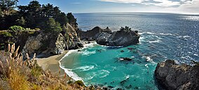
 The park's McWay Cove with McWay Falls | |
| Location | Monterey County, California, United States |
| Nearest city | Carmel-by-the-Sea, California |
| Coordinates | 36°10′15″N 121°40′23″W / 36.17083°N 121.67306°W |
| Area | 3,762 acres (1,522 ha) |
| Established | 1962 |
| Governing body | California Department of Parks and Recreation |
Julia Pfeiffer Burns State Park is a state park in California, 12 miles south of Pfeiffer Big Sur State Park on California's Pacific coast.[1] A main feature of the park is McWay Falls, which drops over a cliff of 80 feet (24 m) into the Pacific Ocean. The park is also home to 300-foot (90 m) redwoods which are over 2,500 years old.[2] The park is named after Julia Pfeiffer Burns, a respected resident and rancher in the Big Sur region in the early 20th century, who lived in the area for much of her life until her death in 1928.[3] The 3,762-acre (1,522 ha) park was established in 1962.[4]
- ^ "See Monterey: Pfeiffer Big Sur State Park". Archived from the original on September 30, 2011. Retrieved July 25, 2014.
- ^ Kinneberg, Caroline (August 2010). "America's Most Beautiful Coastal Views". Travel+Lesiure. Retrieved July 4, 2012.
- ^ "Julia Pfeiffer Burns SP". California State Parks. Retrieved July 4, 2012.
- ^ "California State Park System Statistical Report: Fiscal Year 2009/10" (PDF). California State Parks: 24. Retrieved July 4, 2012.
{{cite journal}}: Cite journal requires|journal=(help)

