South Point Complex | |
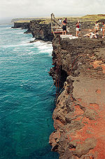
 Rocky cliffs of Ka Lae | |
| Location | Big Island of Hawaii |
|---|---|
| Nearest city | Nā'ālehu |
| Coordinates | 18°54′40″N 155°40′52″W / 18.9111°N 155.681111°W |
| Area | 710 acres (290 ha) |
| NRHP reference No. | 66000291[1] |
| Significant dates | |
| Added to NRHP | October 15, 1966[1] |
| Designated NHLD | December 29, 1962[2] |


Ka Lae (Hawaiian: the point), also known as South Point, is the southernmost point of the Big Island of Hawaii and of the 50 United States. The Ka Lae area is registered as a National Historic Landmark District under the name South Point Complex. The area is also known for its strong ocean currents and winds and is the home of a wind farm.
- ^ a b "National Register Information System". National Register of Historic Places. National Park Service. July 9, 2010.
- ^ "South Point Complex". National Historic Landmark summary listing. National Park Service. Archived from the original on May 11, 2011. Retrieved July 4, 2008.
