Kafr Bara
| |
|---|---|
| A transcription(s) | |
| • ISO 259 | Káper Báraˀ |
| • Also spelled | Kafar Bara (official) Kfar Bara (unofficial) |
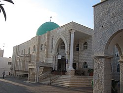
 A mosque of Kafr Bara in 2010 | |
| Coordinates: 32°7′50″N 34°58′19″E / 32.13056°N 34.97194°E | |
| Grid position | 147/170 PAL |
| District | Central |
| Area | |
• Total | 9,387 dunams (9.387 km2 or 3.624 sq mi) |
| Population (2022)[1] | |
• Total | 3,946 |
| • Density | 420/km2 (1,100/sq mi) |
| Name meaning | Khirbet Kafr Bara, "The ruin of the village of Bara"[2] |
Kafr Bara or Kfar Bara (Arabic: كفر برا; Hebrew: כַּפְר בַּרָא) is an Arab locality in Israel in situated in its Central District. The small village, located near the Green Line, is often considered a part of the Arabs' Little Triangle along with the cities of Kafr Qasim and Jaljulia. In 2022 its population was 3,946.[1]
- ^ a b "Regional Statistics". Israel Central Bureau of Statistics. Retrieved 21 March 2024.
- ^ Palmer, 1881, p. 234
