Kaikohe | |
|---|---|
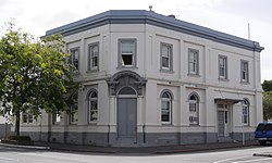
 Bank of New Zealand Building | |
 | |
| Coordinates: 35°24′27″S 173°47′59″E / 35.40750°S 173.79972°E | |
| Country | New Zealand |
| Region | Northland Region |
| District | Far North District |
| Ward | Kaikohe/Hokianga |
| Electorates | |
| Government | |
| • Territorial Authority | Far North District Council |
| • Regional council | Northland Regional Council |
| Area | |
| • Total | 5.92 km2 (2.29 sq mi) |
| Population (June 2024)[2] | |
| • Total | 4,890 |
| • Density | 830/km2 (2,100/sq mi) |
| Postcode(s) | 0405 |

Kaikohe is the seat of the Far North District of New Zealand, situated on State Highway 12 about 260 kilometres (160 mi) from Auckland, and about 85 kilometres (53 mi) from Whangārei. It is the largest inland town and highest community above sea level in the Northland Region. With a population of over 4000 people,[2] Kaikohe is a shopping and service centre for an extensive farming district and is sometimes referred to as "the hub of the north".[3]
- ^ Cite error: The named reference
Areawas invoked but never defined (see the help page). - ^ a b "Aotearoa Data Explorer". Statistics New Zealand. Retrieved 26 October 2024.
- ^ "EDITORIAL – Hard-hit Kaikohe needs to reinvent itself". The Northern Advocate. 11 November 2007.