| Kajaki Dam | |
|---|---|
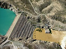
 Aerial view of the Kajaki Dam in 2007 | |
| Country | Afghanistan |
| Location | Kajaki District, Helmand Province |
| Coordinates | 32°19′19″N 65°7′8″E / 32.32194°N 65.11889°E |
| Purpose | Irrigation and electricity |
| Status | Operational |
| Construction began | 1951 |
| Opening date | 1953 |
| Owner(s) | Ministry of Energy and Water |
| Dam and spillways | |
| Type of dam | Embankment |
| Impounds | Helmand River |
| Height | 100 m (330 ft) |
| Length | 270 m (890 ft) |
| Width (crest) | 10 m (33 ft) |
| Reservoir | |
| Total capacity | 1,715×106 m3 (1,390,373 acre⋅ft) |
| Active capacity | 1,134×106 m3 (919,349 acre⋅ft) |
| Power Station | |
| Operator(s) | Helmand and Arghandab Valley Authority (HAVA) |
| Commission date | 1975 |
| Turbines | 2 x 16.5 MW, 1 x 18.5 MW Francis-type[1] |
| Installed capacity | 51 MW[2][3] |
The Kajaki Dam is "an earth and rockfill embankment type dam"[4] located on the Helmand River in the Kajaki District of Helmand Province in Afghanistan, about 161 km (100 mi) northwest of Kandahar. It has a hydroelectric power station, which is operated by the Helmand and Arghandab Valley Authority through the Ministry of Energy and Water.
Kajaki Dam has a dual function, to provide electricity and to irrigate some 263,045 ha (650,000 acres) or 1,800 km2 (690 sq mi) of an otherwise arid land. Water discharging from the dam traverses some 300 miles (500 km) of downstream irrigation canals feeding farmland. As of July 2022[update] it produces up to 151 megawatts (MW) of electricity.[2][3]
The dam is 100 m (328 ft) high and 270 m (890 ft) long, with a gross storage capacity of 1,715,000,000 m3 (1,390,373 acre⋅ft) of fresh water. The dam controls the output of the main watershed which feeds the Sistan Basin.
- ^ "Hydroelectric Power Plants in Afghanistan". IndustCards. Archived from the original on 6 December 2012. Retrieved 7 February 2012.
- ^ a b Cite error: The named reference
Kajaki Dam power generation capacity surges to 151MWwas invoked but never defined (see the help page). - ^ a b Cite error: The named reference
Second Phase of Kajaki Power Dam Completedwas invoked but never defined (see the help page). - ^ "Projects Completed". CEYTUN Construction & Trade Inc. 2018. Retrieved 2023-05-22.
