Kakanui | |
|---|---|
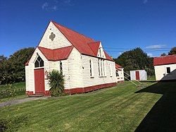
 Kakanui Presbyterian Church | |
 | |
| Coordinates: 45°11′S 170°54′E / 45.183°S 170.900°E | |
| Country | New Zealand |
| Region | Otago |
| District | Waitaki District |
| Ward | Corriedale Ward |
| Electorates |
|
| Government | |
| • Territorial authority | Waitaki District Council |
| • Regional council | Otago Regional Council |
| • Mayor of Waitaki | Gary Kircher |
| • Waitaki MP | Miles Anderson |
| • Te Tai Tonga MP | Tākuta Ferris |
| Area | |
| • Total | 2.02 km2 (0.78 sq mi) |
| Population (June 2023)[2] | |
| • Total | 450 |
| • Density | 220/km2 (580/sq mi) |
The small town of Kakanui lies on the coast of Otago, in New Zealand, fourteen kilometres to the south of Oamaru. The Kakanui River and its estuary divide the township in two. The part of the settlement south of the river, also known as Kakanui South, formerly "Campbells Bay", was developed as a collection of cribs (holiday homes). A recent increase in the development of subdivisions has increased the density of dwellings within South Kakanui.[3][4]
The Kakanui River reaches the sea near the town, and the low range known as the Kakanui Mountains stretches inland from south of Oamaru towards the Maniototo. Kai Tahu used to temporarily occupy Kakanui as they travelled north and south, as evidenced by the midden on the north side of the estuary.
The area around Kakanui has a reputation for its limestone formations, and produces many fossils. Quarrying formerly took place. The rich and fertile soil of the area around the river has physical properties which make it perfect for use in sports grounds, especially cricket pitches. Many of New Zealand's top cricket venues use Kakanui soil on their wicket blocks.
- ^ Cite error: The named reference
Areawas invoked but never defined (see the help page). - ^ "Subnational population estimates (RC, SA2), by age and sex, at 30 June 1996-2023 (2023 boundaries)". Statistics New Zealand. Retrieved 25 October 2023. (regional councils); "Subnational population estimates (TA, SA2), by age and sex, at 30 June 1996-2023 (2023 boundaries)". Statistics New Zealand. Retrieved 25 October 2023. (territorial authorities); "Subnational population estimates (urban rural), by age and sex, at 30 June 1996-2023 (2023 boundaries)". Statistics New Zealand. Retrieved 25 October 2023. (urban areas)
- ^ http://www.waitaki.govt.nz/NR/rdonlyres/F44D4DBF8-738F-4CD7-A898-102CC642D020/35820/SubdivisionSummaryv8.pdf [dead link]
- ^ "Visioning Workshop Kakanui, Meheno and Herbert Workshop Report" (PDF). 30 October 2005. Archived from the original (PDF) on 14 October 2008. Retrieved 30 June 2008.