Kalaeloa Airport Kahua Mokulele o Kalaeloa | |||||||||||||||||||
|---|---|---|---|---|---|---|---|---|---|---|---|---|---|---|---|---|---|---|---|
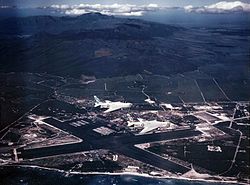
 Two North American FJ-4 Fury's pass Naval Air Station Barbers Point (now Kalaeloa Airport) in January 1958. | |||||||||||||||||||
| Summary | |||||||||||||||||||
| Airport type | Public | ||||||||||||||||||
| Owner/Operator | Hawaii Department of Transportation | ||||||||||||||||||
| Location | Kapolei, Hawaii | ||||||||||||||||||
| Elevation AMSL | 30 ft / 9 m | ||||||||||||||||||
| Coordinates | 21°18′26″N 158°04′13″W / 21.30722°N 158.07028°W | ||||||||||||||||||
| Website | hawaii | ||||||||||||||||||
| Maps | |||||||||||||||||||
 FAA airport diagram | |||||||||||||||||||
 | |||||||||||||||||||
| Runways | |||||||||||||||||||
| |||||||||||||||||||
| Statistics (ending 31 December 2008) | |||||||||||||||||||
| |||||||||||||||||||
Kalaeloa Airport (IATA: JRF, ICAO: PHJR, FAA LID: JRF), also called John Rodgers Field (the original name of Honolulu International Airport) and formerly Naval Air Station Barbers Point, is a joint civil-military regional airport of the State of Hawaiʻi established on July 1, 1999, to replace the Ford Island NALF facilities which closed on June 30 of the same year. Located on the site of the developing unincorporated town of Kalaeloa and nestled between the Honolulu communities of ʻEwa Beach, Kapolei and Campbell Industrial Park in West Oʻahu, most flights to Kalaeloa Airport originate from commuter airports on the other Hawaiian islands. While Kalaeloa Airport is primarily a commuter facility used by unscheduled air taxis, general aviation and transient and locally based military aircraft, the airport saw first-ever scheduled airline service begin on July 1, 2014, with Mokulele Airlines operating flights to Kahului Airport on Maui.
It is included in the Federal Aviation Administration (FAA) National Plan of Integrated Airport Systems for 2017–2021, in which it is categorized as a regional reliever facility.[2]
- ^ FAA Airport Form 5010 for JRF PDF
- ^ "List of NPIAS Airports" (PDF). FAA.gov. Federal Aviation Administration. 21 October 2016. Retrieved 23 December 2016.