| Kalbarri National Park Western Australia | |
|---|---|
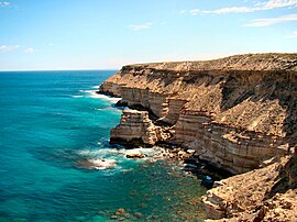
 From the coastal section of the park, cliffs running south from the town of Kalbarri. | |
 | |
| Nearest town or city | Kalbarri |
| Coordinates | 27°47′05″S 114°14′45″E / 27.78472°S 114.24583°E |
| Established | 1963 |
| Area | 1,830.05 km2 (706.6 sq mi)[1] |
| Managing authorities | Department of Parks and Wildlife (DPaW) |
| Website | Kalbarri National Park |
| See also | List of protected areas of Western Australia |
Kalbarri National Park is located 485 kilometres (301 mi) north of Perth, in the Mid West region of Western Australia.
The major geographical features of the park include the Murchison River gorge which runs for nearly 80 kilometres (50 mi) on the lower reaches of the Murchison River. Spectacular coastal cliffs are located on the coast near the mouth of the Murchison River and the town of Kalbarri.
There is also an eponymous locality of the Shire of Northampton, but the boundaries of the national park and the locality are not identical.[2][3][4]
- ^ "Department of Environment and Conservation 2012–13 Annual Report". Department of Environment and Conservation (PDF file p. 49: www.dpaw.wa.gov.au/images/documents/about/annual-report/2013/20130151_Annual_Report_WEB.pdf). 2013. p. 49. Retrieved 3 April 2014.
- ^ "SLIP Map". maps.slip.wa.gov.au. Landgate. Retrieved 25 September 2024.
- ^ "Terrestrial CAPAD 2022 WA summary". www.dcceew.gov.au/. Department of Climate Change, Energy, the Environment and Water. Retrieved 25 September 2024.
- ^ "Australian Protected Areas Dashboard". www.dcceew.gov.au/. Department of Climate Change, Energy, the Environment and Water. Retrieved 25 September 2024.
