Kalimpong | |
|---|---|
|
Clockwise from top-left: Mangal Dham Mandir, Morgan House in Kalimpong, Hanuman Mandir, view from Rishyap, Neora Valley National Park | |
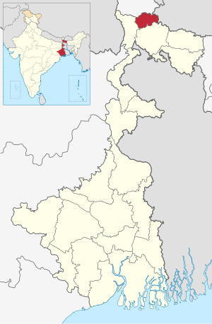
 Location of Kalimpong district in West Bengal | |
| Coordinates: 27°04′N 88°28′E / 27.06°N 88.47°E | |
| Country | |
| State | |
| Division | Jalpaiguri |
| Headquarters | Kalimpong |
| Government | |
| • Subdivisions | Kalimpong Sadar |
| • CD Blocks | Kalimpong I, Kalimpong II, Gorubathan |
| • Lok Sabha constituencies | Darjeeling |
| • Vidhan Sabha constituencies | Kalimpong |
| Area | |
| • Total | 1,044.60 km2 (403.32 sq mi) |
| Population (2011)[1] | |
| • Total | 251,642 |
| • Density | 240/km2 (620/sq mi) |
| Demographics | |
| • Literacy | 78.57 per cent |
| • Sex ratio | 949 ♂/♀ |
| Languages | |
| • Official | Bengali,[2][3] Nepali[3] |
| • Additional official | English[2] |
| Time zone | UTC+05:30 (IST) |
| Website | kalimpong |

Kalimpong district is a district in the state of West Bengal, India. In 2017, it was carved out as a separate district to become the 21st district of West Bengal.[4][5] The district is headquartered at Kalimpong, which grew to prominence as a market town for Indo-Tibetan trade during the British period. It is bounded by Pakyong district of Sikkim in the north, Bhutan in the east, Darjeeling district in the west, and Jalpaiguri district in the south.
The district consists of the Kalimpong municipality and four community development blocks: Kalimpong I, Kalimpong II, Gorubathan and Pedong. The towns and villages in Kalimpong District are: Kalimpong, Gorubathan, Melli Bazar, Teesta Bazar, Algarah, Labha, Samsing and Rambi.
- ^ Cite error: The named reference
census2011was invoked but never defined (see the help page). - ^ a b "Fact and Figures". Wb.gov.in. Retrieved 5 July 2019.
- ^ a b "52nd Report of the Commissioner for Linguistic Minorities in India" (PDF). Nclm.nic.in. Ministry of Minority Affairs. p. 85. Archived from the original (PDF) on 25 May 2017. Retrieved 5 July 2019.
- ^ "Carved out of Darjeeling, Kalimpong a district today". Times of India. Retrieved 14 February 2017.
- ^ "Kalimpong district may stoke Gorkhaland fire". Hindustan Times. 13 February 2017.


