Kalispell, Montana
Ql̓ispé Kqayaqawakⱡuʔnam | |
|---|---|
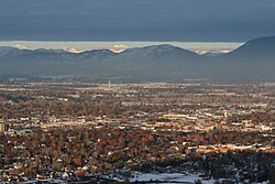
 Kalispell looking northeast toward Glacier National Park from Lone Pine State Park | |
 Location of Kalispell within Flathead County | |
| Coordinates: 48°11′52″N 114°18′58″W / 48.19778°N 114.31611°W | |
| Country | United States |
| State | Montana |
| County | Flathead |
| Government | |
| • Mayor | Mark Johnson |
| Area | |
• City | 12.64 sq mi (32.74 km2) |
| • Land | 12.56 sq mi (32.52 km2) |
| • Water | 0.09 sq mi (0.22 km2) |
| Elevation | 2,956 ft (901 m) |
| Population (2020) | |
• City | 24,558 |
| • Density | 1,955.88/sq mi (755.20/km2) |
| • Metro | 104,357 |
| Time zone | UTC−7 (Mountain (MST)) |
| • Summer (DST) | UTC−6 (MDT) |
| ZIP codes | 59901-59904 |
| Area code | 406 |
| FIPS code | 30-40075 |
| GNIS feature ID | 0785622[2] |
| Website | www |
Kalispell (/ˈkæləˌspɛl, ˌkæləˈspɛl/, Montana Salish: Ql̓ispé, Kutenai language: Kqayaqawakⱡuʔnam[4]) is a city in Montana and the county seat of Flathead County, Montana, United States.[5] The 2020 census put Kalispell's population at 24,558.[6] Among cities in Montana, it is the 8th largest by area, 7th most populous, and 8th fastest growing from 2010 to 2020.[6] In Montana's northwest region, it is the largest city and the commercial center of the Kalispell Micropolitan Statistical Area.[3] The name Kalispell is a Salish word meaning "flat land above the lake".
- ^ "ArcGIS REST Services Directory". United States Census Bureau. Retrieved September 5, 2022.
- ^ a b U.S. Geological Survey Geographic Names Information System: Kalispell, Montana
- ^ a b "Metropolitan and Micropolitan Statistical Areas". Retrieved November 5, 2021.
- ^ Ktunaxa Nation Official Website - Territory Map
- ^ "Find a County". National Association of Counties. Archived from the original on May 31, 2011. Retrieved June 7, 2011.
- ^ a b "Census Quick Facts: Kalispel City, Montana". census.gov. Retrieved August 12, 2022.