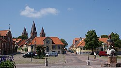
Kalundborg Municipality
Kalundborg Kommune (Danish) | |
|---|---|
 | |
 | |
| Coordinates: 55°40′50″N 11°05′53″E / 55.68064°N 11.09797°E | |
| Country | Denmark |
| Region | Zealand |
| Established | 1 January 2007 |
| Seat | Kalundborg |
| Government | |
| • Mayor | Martin Damm (V) |
| Area | |
| • Total | 604 km2 (233 sq mi) |
| Population (1 January 2024)[1] | |
| • Total | 48,309 |
| • Density | 80/km2 (210/sq mi) |
| Time zone | UTC+1 (CET) |
| • Summer (DST) | UTC+2 (CEST) |
| Municipal code | 326 |
| Website | www |
Kalundborg Municipality (Danish: Kalundborg Kommune) is a kommune in the Region Sjælland on the west coast of the island of Zealand in Denmark. The municipality covers an area of 604 km2 (233 sq mi),[2] and has a total population of 48,309 (1 January 2024).[1] Its mayor is Martin Damm, a member of Venstre. The main town and the site of its municipal council is the city of Kalundborg.
The municipality is surrounded by water on three sides:
- Samsø Bælt— the strait which separates the municipality from the island of Samsø— and Sejerø Bay (Sejerø Bugt) — the bay in which the island of Sejerø is located) to the north
- The Great Belt (Storebælt)— the strait which separates Zealand from the island of Funen) and the Kattegat to the west
- Jammerland Bay (Jammerland Bugt) to the south.
The municipalities of Samsø to the northwest, and Juelsminde on the Jutland peninsula to the west are thus also Kalundborg's municipal neighbors, albeit separated by water.
Ferry lines connect the municipality to Aarhus on the Jutland peninsula, and to the island of Samsø at the central harbour in Kalundborg. The harbour is conveniently located near the Kalundborg train station, which connects to the cities of Holbæk and Copenhagen. A large industrial zone, including a South Harbour?, is located south of the town's central area.
On 1 January 2007 Kalundborg municipality was, as the result of Kommunalreformen ("The Municipal Reform" of 2007), merged with existing Gørlev, Hvidebæk, Bjergsted, and Høng municipalities to form the new Kalundborg municipality.
- ^ a b BY2: Population 1. January by municipalities The Mobile Statbank from Statistics Denmark
- ^ "Kalundborg - ud til vandet, midt i landet". kalundborg.dk (in Danish). Retrieved 27 April 2018.
