| Kangaroo Island Council South Australia | |||||||||||||||
|---|---|---|---|---|---|---|---|---|---|---|---|---|---|---|---|
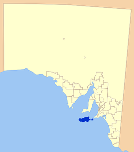
 Location of Kangaroo Island Council | |||||||||||||||
| • Density | 1,11/km2 (290/sq mi) | ||||||||||||||
| Established | 1996 | ||||||||||||||
| Area | 4,400.1 km2 (1,698.9 sq mi) | ||||||||||||||
| Mayor | Michael Pengilly[1] | ||||||||||||||
| Council seat | Kingscote | ||||||||||||||
| Region | Fleurieu and Kangaroo Island[2] | ||||||||||||||
| State electorate(s) | Mawson [3] | ||||||||||||||
| Federal division(s) | Mayo[4] | ||||||||||||||
| Website | Kangaroo Island Council | ||||||||||||||
| |||||||||||||||
The Kangaroo Island Council is a local government area in South Australia that covers the entirety of Kangaroo Island, 13 km off the coast of the mainland. The council was formed on the 28 November 1996 by the amalgamation of the District Council of Kingscote and the District Council of Dudley. Its first meeting held on 11 December 1996. [5]
The seat of the council is located in the island's largest town, Kingscote. The district's population at the 2016 census was approximately 4,700.[6]
- ^ "Elected Members". Kangaroo Island Council. Retrieved 9 April 2016.
- ^ "Fleurieu and Kangaroo Island SA Government region" (PDF). The Government of South Australia. Retrieved 10 October 2014.
- ^ Mawson (Map). Electoral District Boundaries Commission. 2016. Retrieved 2 March 2018.
- ^ "Federal electoral division of Mayo, boundary gazetted 16 December 2011" (PDF). Australian Electoral Commission. Retrieved 2 August 2015.
- ^ Kangaroo Island Council. "About Council". Retrieved 3 December 2015.
- ^ Australian Bureau of Statistics (27 June 2017). "Kangaroo Island (DC)". 2016 Census QuickStats. Retrieved 16 November 2017.