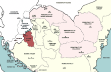
| Kanije Eyalet ایالت قنیژه (Ottoman Turkish) Kanizsai ejálet (Hungarian) Kaniški ejalet (Croatian) | |||||||||||
|---|---|---|---|---|---|---|---|---|---|---|---|
| Eyalet of the Ottoman Empire | |||||||||||
| 1600–1690 | |||||||||||
 The Kanije Eyalet in 1683 | |||||||||||
| Capital | Kanije (Hungarian: Kanizsa, modern Nagykanizsa) | ||||||||||
| Area | |||||||||||
| • Coordinates | 46°27′N 16°59′E / 46.450°N 16.983°E | ||||||||||
| History | |||||||||||
• Established | 1600 | ||||||||||
• Disestablished | 1690 | ||||||||||
| |||||||||||
| Today part of | Croatia Hungary | ||||||||||

The Kanije Eyalet (Ottoman Turkish: ایالت قنیژه; Eyālet-i Ḳanije[1]) was an administrative territorial entity of the Ottoman Empire formed in 1600 and existing until the 1699 Treaty of Karlowitz. It included parts of present-day Hungary and Croatia
- ^ "Some Provinces of the Ottoman Empire". Geonames.de. Archived from the original on 28 September 2013. Retrieved 25 February 2013.