Kapolei | |
|---|---|
| Kapolei[1] | |
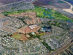
 Aerial photo of Kapolei neighborhood | |
| Nickname(s): The Second City of Oʻahu, Hawaiʻi's e-City[2] | |
| Coordinates: 21°20′05″N 158°04′51″W / 21.33472°N 158.08083°W | |
| Country | United States |
| State | Hawaiʻi |
| County | Honolulu |
| Area | |
• Total | 4.37 sq mi (11.32 km2) |
| • Land | 4.37 sq mi (11.32 km2) |
| • Water | 0.00 sq mi (0.00 km2) |
| Elevation | 51 ft (16 m) |
| Population (2020) | |
• Total | 21,411 |
| • Density | 4,900.66/sq mi (1,892.00/km2) |
| Time zone | UTC−10 (Hawaii–Aleutian) |
| ZIP code | 96707 |
| Area code | 808 |
| FIPS code | 15-30300 |

Kapolei (Hawaiian pronunciation: [kəpoˈlej]) is a planned community in the City and County of Honolulu, Hawaiʻi, United States, on the island of Oʻahu. It is colloquially known as the "second city" of Oʻahu,[4] in relation to Honolulu. For statistical purposes, the United States Census Bureau has defined Kapolei as a census-designated place (CDP) within the consolidated city-county of Honolulu.
The community takes its name from a volcanic cone, Puʻu o Kapolei. In the Hawaiian language, puʻu means "hill" and Kapo lei means "beloved Kapo". According to legend, Kapo, Goddess of Fertility was sister to Pele, Goddess of Fire and Nāmaka, Goddess of the Sea.
Much of the land is part of the estate of industrialist James Campbell. Kapolei's major developer is Kapolei Property Development, a subsidiary of James Campbell Company.[5] Kapolei sits primarily upon former sugarcane and pineapple fields.
- ^ "Hawaii Statewide Map of 2010 CDPs" (PDF). State of Hawaii Office of Planning. Hawaii Statewide GIS Program. p. 2. Retrieved 4 March 2020.
- ^ "The City of Kapolei". Kapolei Property Development.
- ^ "2020 U.S. Gazetteer Files". United States Census Bureau. Retrieved December 18, 2021.
- ^ "Kapolei Skyscraper Page". Skyscraper Source Media. Retrieved 2008-01-27.
- ^ "About Us". Kapolei Property Development. Retrieved 2008-01-27.
