Karamea | |
|---|---|
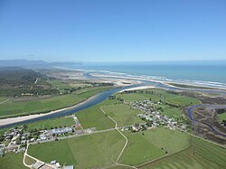
 Market Cross, Karamea, and the Ōtūmahana Estuary | |
 | |
| Coordinates: 41°15′S 172°07′E / 41.250°S 172.117°E | |
| Country | New Zealand |
| Region | West Coast |
| District | Buller District |
| Ward | Seddon |
| Electorates | |
| Government | |
| • Territorial Authority | Buller District Council |
| • Regional council | West Coast Regional Council |
| • Mayor of Buller | Jamie Cleine |
| • West Coast-Tasman MP | Maureen Pugh |
| • Te Tai Tonga MP | Tākuta Ferris |
| Area | |
| • Total | 66.08 km2 (25.51 sq mi) |
| Population (June 2024)[2] | |
| • Total | 430 |
| • Density | 6.5/km2 (17/sq mi) |
Karamea is a town on the West Coast of the South Island of New Zealand. It is the northernmost settlement of any real size on the West Coast, and is located 96 kilometres (60 mi) northeast by road from Westport. Apart from a narrow coastal strip, the town of Karamea and its local area are completely surrounded to the south, east and north by Kahurangi National Park.
The town is located on the coastal plain adjacent to the Karamea River and the Ōtūmahana Estuary. The town consists of two small settlements, Market Cross and Karamea proper, located about 1 kilometre (0.62 mi) apart. Up the Karamea River are the farming areas of Arapito (on the south bank) and Umere (on the north bank).
Karamea is a gateway to the Kahurangi National Park, and provides a base for visitors coming to walk or mountain bike the Heaphy Track, or see popular local attractions such as the Ōpārara Basin, Ōpārara Arches, the Fenian Track and caves, the Big Rimu Walk and the coastal scenery north of Kōhaihai on the Heaphy Track.
- ^ Cite error: The named reference
Areawas invoked but never defined (see the help page). - ^ "Aotearoa Data Explorer". Statistics New Zealand. Retrieved 26 October 2024.