Karikari Peninsula | |
|---|---|
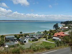
 Rangaunu harbour and Rangiputa settlement | |
 | |
| Coordinates: 34°51′0″S 173°25′0″E / 34.85000°S 173.41667°E | |
| Country | New Zealand |
| Region | Northland Region |
| District | Far North District |
| Ward | Te Hiku |
| Community | Te Hiku |
| Subdivision | Whatuwhiwhi |
| Electorates | |
| Government | |
| • Territorial Authority | Far North District Council |
| • Regional council | Northland Regional Council |
| • Mayor of Far North | Moko Tepania |
| • Northland MP | Grant McCallum |
| • Te Tai Tokerau MP | Mariameno Kapa-Kingi |
| Area | |
• Total | 174.44 km2 (67.35 sq mi) |
| Population (June 2024)[2] | |
• Total | 1,470 |
| • Density | 8.4/km2 (22/sq mi) |
The Karikari Peninsula on the east coast of the far north of Northland, New Zealand, is between Rangaunu Harbour to the west, and Doubtless Bay to the southeast. It is a right-angled land mass of two relatively distinct parts. The rocky northern part, which has an east–west orientation and is approximately 17 km long, was originally an island[3] but is now connected to the mainland by a low sandy tombolo approximately 11 km long, which has a north–south orientation.[4][5][6] The spiritually significant Puwheke sits high above the north-facing beaches.[7]
- ^ Cite error: The named reference
Areawas invoked but never defined (see the help page). - ^ "Aotearoa Data Explorer". Statistics New Zealand. Retrieved 26 October 2024.
- ^ "Mangonui and district". Te Ara: The Encyclopedia of New Zealand.
- ^ Parkes, W. F. (c. 1965). The Visitors' Guide to the Far North - Mangonui County (3rd ed.). p. 26.
- ^ Peter Dowling, ed. (2004). Reed New Zealand Atlas. Reed Books. pp. map 3. ISBN 0-7900-0952-8.
- ^ Roger Smith, GeographX (2005). The Geographic Atlas of New Zealand. Robbie Burton. pp. map 17. ISBN 1-877333-20-4.
- ^ "Puwheke". Archived from the original on 30 July 2012. Retrieved 24 November 2011.