Karluk
Kal’uq, Kal’ut | |
|---|---|
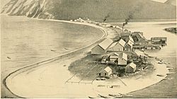
 Karluk sandspit in the late 1800s showing cannery and village; the source termed the Karluk River the "River of Life" due to the dense salmon run | |
| Coordinates: 57°34′41″N 154°21′45″W / 57.57806°N 154.36250°W | |
| Country | United States |
| State | Alaska |
| Borough | Kodiak Island |
| Government | |
| • Borough mayor | Jerrol Friend[1] |
| • State senator | Gary Stevens (R) |
| • State rep. | Louise Stutes (R) |
| Area | |
| • Total | 57.86 sq mi (149.86 km2) |
| • Land | 55.94 sq mi (144.89 km2) |
| • Water | 1.92 sq mi (4.97 km2) |
| Population (2020) | |
| • Total | 27 |
| • Density | 0.48/sq mi (0.19/km2) |
| Time zone | UTC-9 (Alaska (AKST)) |
| • Summer (DST) | UTC-8 (AKDT) |
| ZIP code | 99608 |
| Area code | 907 |
| FIPS code | 02-37540 |
Karluk (Kal’uq or Kal’ut[3] in Alutiiq; Russian: Карлук) is a census-designated place (CDP) in Kodiak Borough, Kodiak Island, Alaska, United States. The population was 37 at the 2010 census,[4] up from 27 in 2000.
- ^ 2015 Alaska Municipal Officials Directory. Juneau: Alaska Municipal League. 2015. p. 11.
- ^ "2020 U.S. Gazetteer Files". United States Census Bureau. Retrieved October 29, 2021.
- ^ ANLC : Alaska Native Place Names
- ^ "Geographic Identifiers: 2010 Demographic Profile Data (DP-1): Karluk CDP, Alaska". U.S. Census Bureau, American Factfinder. Archived from the original on February 10, 2020. Retrieved March 21, 2013.
