Kastro-Kyllini
Κάστρο-Κυλλήνη | |
|---|---|
 | |
| Coordinates: 37°56′N 21°9′E / 37.933°N 21.150°E | |
| Country | Greece |
| Administrative region | West Greece |
| Regional unit | Elis |
| Municipality | Andravida-Kyllini |
| Area | |
| • Municipal unit | 49.322 km2 (19.043 sq mi) |
| Elevation | 20 m (70 ft) |
| Population (2021)[1] | |
| • Municipal unit | 3,272 |
| • Municipal unit density | 66/km2 (170/sq mi) |
| Time zone | UTC+2 (EET) |
| • Summer (DST) | UTC+3 (EEST) |
| Postal code | 270 68, 270 50 |
| Area code(s) | 26230 |
| Vehicle registration | ΗΑ |
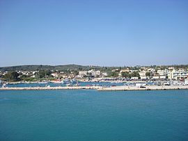
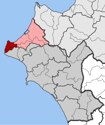
Kastro-Kyllini (Greek: Κάστρο-Κυλλήνη) is a former municipality in Elis, West Greece, Greece. Since the 2011 local government reform it is part of the municipality Andravida-Kyllini, of which it is a municipal unit.[2] The municipal unit has an area of 49.322 km2.[3] The population was 3,272 in 2021. The municipality Kastro-Kyllini was created in 1999 as part of the Kapodistrias reform from the formerly independent communities Kyllini, Kato Panagia, Kastro and Neochori, that became municipal districts. After the 2011 Kallikratis reform, these municipal districts became (dependent) communities. Its seat of administration was the small port town of Kyllini.
- ^ "Αποτελέσματα Απογραφής Πληθυσμού - Κατοικιών 2021, Μόνιμος Πληθυσμός κατά οικισμό" [Results of the 2021 Population - Housing Census, Permanent population by settlement] (in Greek). Hellenic Statistical Authority. 29 March 2024.
- ^ "ΦΕΚ B 1292/2010, Kallikratis reform municipalities" (in Greek). Government Gazette.
- ^ "Population & housing census 2001 (incl. area and average elevation)" (PDF) (in Greek). National Statistical Service of Greece. Archived from the original (PDF) on 2015-09-21.

