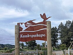
Kaukapakapa | |
|---|---|
 Kaukapakapa sign | |
 | |
| Coordinates: 36°36′58″S 174°29′29″E / 36.61611°S 174.49139°E | |
| Country | New Zealand |
| Region | Auckland Region |
| Ward | Rodney ward |
| Community board | Rodney Local Board |
| Subdivision | Kumeū subdivision |
| Electorates | |
| Government | |
| • Territorial Authority | Auckland Council |
| Area | |
• Total | 5.26 km2 (2.03 sq mi) |
| Population (June 2024)[2] | |
• Total | 1,070 |
| • Density | 200/km2 (530/sq mi) |
Kaukapakapa is a town in the North Island of New Zealand. It is situated in the Rodney ward of the Auckland Region and is around 50 kilometres (31 mi) northwest of Auckland. State Highway 16 passes through the town, connecting it to Helensville about 12 kilometres (7.5 mi) to the south-west, and Araparera about 14 kilometres (8.7 mi) to the north. The North Auckland Line also passes through Kaukapakapa. The Kaukapakapa River flows from the town to the Kaipara Harbour to the west.[3][4]
"Kaukapakapa" is a Māori name meaning "to swim with much splashing".[5] The town is commonly known to the locals in its shortened form "Kaukap";[6] it is sometimes abbreviated to KKK.[7]
- ^ Cite error: The named reference
Areawas invoked but never defined (see the help page). - ^ "Aotearoa Data Explorer". Statistics New Zealand. Retrieved 26 October 2024.
- ^ Peter Dowling, ed. (2004). Reed New Zealand Atlas. Reed Books. map 11. ISBN 0-7900-0952-8.
- ^ Roger Smith, GeographX (2005). The Geographic Atlas of New Zealand. Robbie Burton. map 34. ISBN 1-877333-20-4.
- ^ Reed, A.W. (1996) The Reed Dictionary of Mǎori Place Names: Te Papakupu Ingoa Wǎhi Mǎori a Reed (3rd ed.). Reed Books: Auckland, New Zealand
- ^ "Kaukapakapa Travel Guide". Jasons Travel Media.
- ^ Bioletti, Harry (1992). Rodney Coast to Coast. p. 77-87. ISBN 0-473-01296-0.