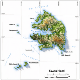
 Map of Kawau Island | |
| Geography | |
|---|---|
| Coordinates | 36°25′24″S 174°50′50″E / 36.4232163°S 174.8472404°E |
| Length | 8 km (5 mi) |
| Width | 5 km (3.1 mi) |
| Highest elevation | 182 m (597 ft) |
| Highest point | Grey Heights |
| Administration | |
| Demographics | |
| Population | 150 (June 2024)[1] |
Kawau Island is in the Hauraki Gulf, close to the north-eastern coast of the North Island of New Zealand. At its closest point it lies 1.4 km (0.87 mi) off the coast of the Northland Peninsula, just south of Tāwharanui Peninsula, and about 8 km (5.0 mi) by sea journey from Sandspit Wharf, and shelters Kawau Bay to the north-east of Warkworth. It is 40 km (25 mi) north of Auckland. Mansion House in the Kawau Island Historic Reserve is an important historic tourist attraction. Almost every property on the Island relies on direct access to the sea. There are only two short roads serving settlements at Schoolhouse Bay and South Cove, and most residents have private wharves for access to their front door steps.
The island is named after the Māori word for the shag.[2]
A regular ferry service operates to the island from Sandspit Wharf on the mainland, as do water taxi services.[3]
- ^ "Aotearoa Data Explorer". Statistics New Zealand. Retrieved 26 October 2024.
- ^ "The Hauraki Gulf Marine Park, Part 2". Inset to The New Zealand Herald. 3 March 2010. p. 12.
- ^ Cite error: The named reference
Kawau Islandwas invoked but never defined (see the help page).
