| Kazusa Province 上総国 | |||||||||
|---|---|---|---|---|---|---|---|---|---|
| Province of Japan | |||||||||
| 7th century–1868 | |||||||||
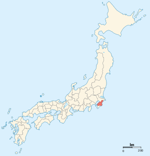
 Map of Japanese provinces (1868) with Kazusa Province highlighted | |||||||||
| Capital | Ichihara District | ||||||||
| History | |||||||||
• Established | 7th century | ||||||||
• Disestablished | 1868 | ||||||||
| |||||||||
| Today part of | Chiba Prefecture | ||||||||
Kazusa Province (上総国, Kazusa-no kuni) was a province of Japan in the area of modern Chiba Prefecture.[1] The province was located in the middle of the Bōsō Peninsula, whose name takes its first kanji from the name of Awa Province and its second from Kazusa and Shimōsa provinces. Its abbreviated form name was Sōshū (総州) or Nansō (南総).[2] The borders of Kazusa Province were defined by Shimōsa Province to the north, the Pacific Ocean to the east, Awa Province to the south, and Tokyo Bay to the west.

Kazusa was classified as one of the provinces of the Tōkaidō. Under the Engishiki classification system, Kazusa was ranked as a "great country" (大国) and a "far country" in relation to its distance from the capital (遠国). Along with Kōzuke and Hitachi, it was originally one of the provinces where an imperial prince was nominally assigned as governor.