| Kebar Valley | |
|---|---|
| Lembah Kebar | |
 A tall grass field, with a large broadleaf forest in the background. | |
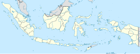
Location in Bird's Head Peninsula Location in Indonesia | |
| Length | 94 to 116 km (58 to 72 mi) |
| Width | 16 to 30 km (9.9 to 18.6 mi) |
| Area | 2,703 km2 (1,044 sq mi) |
| Depth | 500 to 1,400 m (1,600 to 4,600 ft) |
| Geology | |
| Type | Alluvial |
| Geography | |
| Location | Manokwari Regency, Arfak Mountains Regency, Tambrauw Regency, West Papua, Bird's Head Peninsula, Indonesia |
| Population centers | Many tribal villages of the Karoon, Abun, Dore and Wabia people |
| Borders on | Tamrau Mountains (north), Arfak Mountains (south) |
| Coordinates | 0°49′22″S 133°01′15″E / 0.822682°S 133.020742°E |
| Rivers | Kasi River, Api River, Apriri River |
The Kebar Valley (Indonesian: Lembah Kebar) is a large pleistocene/holocene intermontane valley found in the north central region of the Bird's Head Peninsula in the province of Southwest Papua. The valley is enclosed by the fault-bounded Tamrau Mountains at an area of 2,703 square kilometres (1,044 sq mi). Its depth averages from 500 to 600 m (1,600 to 2,000 ft)[1] in the lower sections to around 900 to 1,400 m (3,000 to 4,600 ft) in the upper sections of the valley. The valley is located 130 km (81 mi) west of Manokwari and 190 km (120 mi) east of Sorong. The nearest major village to the valley is Saukorem. A notable path runs through the Kebar Valley connecting Saukorem to the settlement of Andai and reaches an altitude of 1,200 m (3,900 ft). This has created many villages throughout the area, leading to a growing rice production in the central and eastern regions of the valley.[2] From north to south, the Kebar Valley ranges from 16 to 30 km (9.9 to 18.6 mi) wide, and from east to west, it extends from 94 to 116 km (58 to 72 mi) in length.
- ^ Cite error: The named reference
GregersonSterner1998was invoked but never defined (see the help page). - ^ Nova Guinea. Maatschappij ter Bevordering van het Natuurkundig Onderzoek der Nederlandsche Koloniën, E.J. Brill. 1909. p. 1. Retrieved 20 December 2010.

