Keiskammahoek | |
|---|---|
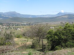
 View of Keiskammahoek from the hill | |
| Coordinates: 32°41′S 27°09′E / 32.683°S 27.150°E | |
| Country | |
| Province | |
| District | Amathole |
| Municipality | Amahlathi |
| Area | |
• Total | 15.67 km2 (6.05 sq mi) |
| Elevation | 670 m (2,200 ft) |
| Population (2011)[1] | |
• Total | 4,429 |
| • Density | 280/km2 (730/sq mi) |
| Racial makeup (2011) | |
| • Black African | 97.1% |
| • Coloured | 1.4% |
| • Indian/Asian | 0.2% |
| • White | 0.3% |
| • Other | 1.0% |
| First languages (2011) | |
| • Xhosa | 94.6% |
| • Afrikaans | 1.8% |
| • English | 1.1% |
| • Other | 2.6% |
| Time zone | UTC+2 (SAST) |
| Postal code (street) | 5670 |
| PO box | 5670 |
| Area code | 040 |

Keiskammahoek (also spelled Keiskamahoek) is a town in the Eastern Cape Province, South Africa.[2] From 1981 until the end of apartheid, the town was part of the Ciskei bantustan.
- ^ a b c d "Main Place Keiskammahoek". Census 2011.
- ^ Keiskammahoek Home Page Archived 8 September 2009 at the Wayback Machine at Amahlathi.co.za


