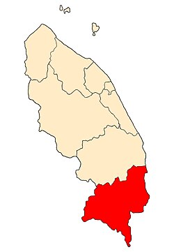
Kemaman District | |
|---|---|
| Daerah Kemaman | |
| Other transcription(s) | |
| • Jawi | كمامن |
| • Chinese | 甘马挽县 |
| • Tamil | கெமாமான் மாவட்டம் |
 Location of Kemaman District in Terengganu | |
 | |
Location of Kemaman District in Malaysia | |
| Coordinates: 4°15′N 103°10′E / 4.250°N 103.167°E | |
| Country | |
| State | |
| Seat | Chukai |
| Local area government | Municipal Council |
| Government | |
| • Yang Dipertua | Ahmad Razin bin Ahmad Azaha[1] |
| Area | |
| • Total | 2,535.60 km2 (979.00 sq mi) |
| Population (2010)[3] | |
| • Total | 166,434 |
| • Estimate (2020)[4] | 215,000 |
| • Density | 66/km2 (170/sq mi) |
| Time zone | UTC+8 (MST) |
| • Summer (DST) | UTC+8 (Not observed) |
| Postcode | 24xxx |
| Calling code | +6-09-8 |
| Vehicle registration plates | T |
Kemaman is a district in Terengganu, Malaysia. Kemaman District is bordered by Dungun District to the north and the state of Pahang to the south and west. It is the southern gateway to the state of Terengganu.
The district administrative seat and the main economic centre of Kemaman is the town of Chukai, near the Terengganu-Pahang state border. Other important towns in this district are Kijal, Kerteh, and Kemasik. The district is administered by the Municipal Council. With a total area of almost 1000 square miles, it is the third largest district after Hulu Terengganu and Dungun bordering the South China Sea.
- ^ "Organisation Chart". mpk.terengganu.gov.my.
- ^ Administrator. "Mengenai Daerah Kemaman". pdtkemaman.terengganu.gov.my.
- ^ "Population Distribution and Basic Demographic Characteristics, 2010" (PDF). Department of Statistics, Malaysia. Archived from the original (PDF) on 22 May 2014. Retrieved 19 April 2012.
- ^ Administrator. "Pengenalan Daerah Dungun". pdtdungun.terengganu.gov.my.


