Kemper County | |
|---|---|
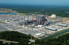
 The Kemper Project power plant. | |
 Location within the U.S. state of Mississippi | |
 Mississippi's location within the U.S. | |
| Coordinates: 32°46′N 88°39′W / 32.76°N 88.65°W | |
| Country | |
| State | |
| Founded | 1833 |
| Named for | Reuben Kemper |
| Seat | De Kalb |
| Largest Town | De Kalb |
| Area | |
| • Total | 767 sq mi (1,990 km2) |
| • Land | 766 sq mi (1,980 km2) |
| • Water | 0.8 sq mi (2 km2) 0.1% |
| Population (2020) | |
| • Total | 8,988 |
| • Density | 12/sq mi (4.5/km2) |
| Time zone | UTC−6 (Central) |
| • Summer (DST) | UTC−5 (CDT) |
| Congressional district | 3rd |
| Website | www |
Kemper County is a county located on the central eastern border of the U.S. state of Mississippi. As of the 2020 census, the population was 8,988.[1] Its county seat is De Kalb.[2] The county is named in honor of Reuben Kemper.[3]
The county is part of the Meridian, MS Micropolitan Statistical Area. In 2010 the Mississippi Public Service Commission approved construction of the Kemper Project, designed to use "clean coal" to produce electricity for 23 counties in the eastern part of the state. As of February 2017[update], it was not completed and had cost overruns. It is designed as a model project to use gasification and carbon-capture technologies at this scale.[4]
East Mississippi Community College is located in Kemper County in the town of Scooba, at the junction of US 45 and Mississippi Highway 16.
- ^ "Census - Geography Profile: Kemper County, Mississippi". United States Census Bureau. Retrieved January 9, 2023.
- ^ "Find a County". National Association of Counties. Archived from the original on May 31, 2011. Retrieved June 7, 2011.
- ^ Gannett, Henry (1905). The Origin of Certain Place Names in the United States. Govt. Print. Off. pp. 173.
- ^ Goldenberg, Suzanne (March 12, 2014). "Can Kemper become the first US power plant to use 'clean coal'?". The Guardian. Retrieved July 14, 2014.