Kent, Washington | |
|---|---|
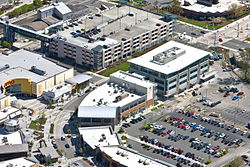
 Kent Station, Kent Regional Library (top right) and Kent Sounder Station in 2009 | |
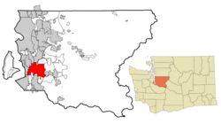
 Location of Kent in King County, Washington | |
| Coordinates: 47°22′58″N 122°13′37″W / 47.38278°N 122.22694°W | |
| Country | United States |
| State | Washington |
| County | King |
| Incorporated | May 28, 1890 |
| Government | |
| • Type | Mayor–council |
| • Mayor | Dana Ralph [1][2] |
| Area | |
| • Total | 34.41 sq mi (89.12 km2) |
| • Land | 33.83 sq mi (87.63 km2) |
| • Water | 0.58 sq mi (1.51 km2) |
| Elevation | 43 ft (13 m) |
| Highest elevation | 500 ft (152 m) |
| Lowest elevation | 0 ft (0 m) |
| Population | |
| • Total | 136,588 |
| • Estimate (2023)[6] | 133,378 |
| • Rank | US: 216th WA: 6th |
| • Density | 3,970/sq mi (1,534/km2) |
| Time zone | UTC–8 (Pacific (PST)) |
| • Summer (DST) | UTC–7 (PDT) |
| ZIP Codes | 98030, 98031, 98032, 98035, 98042, 98064, 98089 |
| Area code | 253 |
| FIPS code | 53-35415 |
| GNIS feature ID | 1530952[4] |
| Website | kentwa |
Kent is a city in King County, Washington, United States. It is part of the Seattle–Tacoma–Bellevue metropolitan area and had a population of 136,588 as of the 2020 census,[5] making it the 4th most populous municipality in greater Seattle and the 6th most populous in Washington state. The city is connected to Seattle, Bellevue and Tacoma via State Route 167 and Interstate 5, Sounder commuter rail, and commuter buses.
Incorporated in 1890, Kent is the second-oldest incorporated city in the county, after the county seat of Seattle.[7] It is generally divided into three areas: West Hill (mixed residential and commercial along Interstate 5), Valley (primarily industrial and commercial with some medium-density residential; significant parkland along Green River), and East Hill (primarily residential with retail).
- ^ "Kent Mayor Dana Ralph". City of Kent, Washington. May 17, 2024. Retrieved May 17, 2024.
- ^ Hunter, Steve (January 3, 2018). "Kent's new Mayor Ralph predicts 'great things' ahead". Kent Reporter. Retrieved June 15, 2019.
- ^ "2023 U.S. Gazetteer Files". United States Census Bureau. Retrieved May 17, 2024.
- ^ a b U.S. Geological Survey Geographic Names Information System: Kent, Washington
- ^ a b "Explore Census Data". United States Census Bureau. Retrieved November 1, 2023.
- ^ Cite error: The named reference
USCensusEst2023was invoked but never defined (see the help page). - ^ "Kent is incorporated on May 28, 1890". historylink.org. History Ink. Retrieved July 29, 2015.
