Kent County | |
|---|---|
 The Kent County Courthouse in Dover in 2006 | |
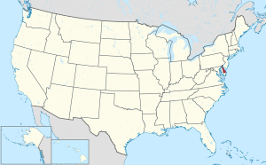
 Location within the U.S. state of Delaware | |
 Delaware's location within the U.S. | |
| Coordinates: 39°06′N 75°30′W / 39.1°N 75.5°W | |
| Country | |
| State | |
| Founded | August 8, 1683 |
| Named for | Kent, England |
| Seat | Dover |
| Largest city | Dover |
| Area | |
| • Total | 798 sq mi (2,070 km2) |
| • Land | 586 sq mi (1,520 km2) |
| • Water | 212 sq mi (550 km2) 26.6% |
| Population (2020) | |
| • Total | 181,851 |
| • Density | 310.33/sq mi (119.82/km2) |
| Time zone | UTC−5 (Eastern) |
| • Summer (DST) | UTC−4 (EDT) |
| Congressional district | At-large |
| Website | www |
Kent County is a county located in the central part of the U.S. state of Delaware. As of the 2020 census, the population was 181,851, making it the least populous county in Delaware.[1] The county seat is Dover,[2] the state capital of Delaware. It is named for Kent, an English county.[3]
Kent County comprises the Dover metropolitan area, which is included in the Philadelphia-Reading-Camden, PA-NJ-DE-MD combined statistical area.[4]
- ^ "Census - Geography Profile: Kent County, Delaware". United States Census Bureau. Retrieved December 18, 2022.
- ^ "Find a County". National Association of Counties. Archived from the original on May 31, 2011. Retrieved June 7, 2011.
- ^ Gannett, Henry (1905). The Origin of Certain Place Names in the United States. Govt. Print. Off. pp. 173.
- ^ "Archived copy" (PDF). Office of Management and Budget. Archived (PDF) from the original on January 21, 2017. Retrieved April 27, 2014 – via National Archives.
{{cite web}}: CS1 maint: archived copy as title (link)

