| Kenton | |
|---|---|
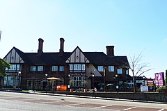
 The Beefeater Travellers Rest pub, and its adjoined Premier Inn hotel - the Travellers’ Rest was once the largest public house in the County of Middlesex[1] | |
Location within Greater London | |
| Population | 35,600 (2015 data, Kenton ward; Kenton East ward; Kenton West ward.)[2] |
| OS grid reference | TQ175885 |
| London borough | |
| Ceremonial county | Greater London |
| Region | |
| Country | England |
| Sovereign state | United Kingdom |
| Post town | HARROW |
| Postcode district | HA3 |
| Dialling code | 020 |
| Police | Metropolitan |
| Fire | London |
| Ambulance | London |
| UK Parliament | |
| London Assembly | |
Kenton is a district in north-west London, England, to the east of Harrow and historically in Middlesex. As with surroundings in Harrow, Wembley and Kingsbury, the area was a product of Metroland suburbia of the early 20th century.[1] Both the London and North Western Railway and Metropolitan Railway reached the area by the 1920s. The main road through Kenton, the east-west Kenton Road, is a busy and important road that links Harrow to the major Edgware Road.[1] The road now forms the boundary between the London boroughs of Harrow and Brent.[3]
- ^ "Ward Profiles and Atlas – London Datastore".
- ^ Ordnance Survey pre-1920s mapping
