Kernville | |
|---|---|
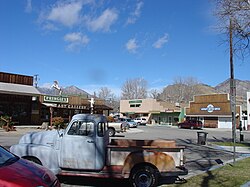
 Downtown Kernville | |
 Location in Kern County and the state of California | |
| Coordinates: 35°45′17″N 118°25′31″W / 35.75472°N 118.42528°W | |
| Country | |
| State | |
| County | Kern |
| Government | |
| • State senator | Melissa Hurtado (D)[1] |
| • Assemblymember | Evan Low (D)[1] |
| • U. S. rep. | Jay Obernolte (R)[2] |
| Area | |
• Total | 12.676 sq mi (32.831 km2) |
| • Land | 12.368 sq mi (32.033 km2) |
| • Water | 0.308 sq mi (0.798 km2) 2.43% |
| Elevation | 2,667 ft (813 m) |
| Population (2020)[5] | |
• Total | 1,549 |
| • Density | 120/sq mi (47/km2) |
| Time zone | UTC-8 (PST) |
| • Summer (DST) | UTC-7 (PDT) |
| ZIP code | 93238 |
| Area codes | 442/760 |
| FIPS code | 06-38310 |
| GNIS feature ID | 1660834 |
| Website | |
| Reference no. | 132 |
Kernville is a census-designated place (CDP) in the southern Sierra Nevada, in Kern County, California, United States.[4] Kernville is located 42 miles (68 km) northeast of Bakersfield,[6] at an elevation of 2,667 feet (813 m).[4] The population was 1,549 at the 2020 United States census,[5] up from 1,395 at the 2010 census, but below the 2000 census total of 1,736.
- ^ a b "Statewide Database". Regents of the University of California. Archived from the original on February 1, 2015. Retrieved April 6, 2015.
- ^ "California's 23rd Congressional District - Representatives & District Map". Civic Impulse, LLC.
- ^ U.S. Census Archived 2012-07-02 at the Wayback Machine
- ^ a b c U.S. Geological Survey Geographic Names Information System: Kernville, California
- ^ a b United States Census Bureau: Kernville CDP, California
- ^ Durham, David L. (1998). California's Geographic Names: A Gazetteer of Historic and Modern Names of the State. Clovis, Calif.: Word Dancer Press. p. 1055-1056. ISBN 1-884995-14-4.
