Kerpen | |
|---|---|
 Bergerhausen Castle | |
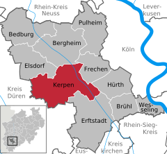
Location of Kerpen within Rhein-Erft-Kreis district  | |
| Coordinates: 50°52′19″N 6°41′46″E / 50.87194°N 6.69611°E | |
| Country | Germany |
| State | North Rhine-Westphalia |
| Admin. region | Köln |
| District | Rhein-Erft-Kreis |
| Subdivisions | 9 |
| Government | |
| • Mayor (2020–25) | Dieter Spürck[1] (CDU) |
| Area | |
| • Total | 113.94 km2 (43.99 sq mi) |
| Elevation | 95 m (312 ft) |
| Population (2023-12-31)[2] | |
| • Total | 67,627 |
| • Density | 590/km2 (1,500/sq mi) |
| Time zone | UTC+01:00 (CET) |
| • Summer (DST) | UTC+02:00 (CEST) |
| Postal codes | 50169, 50170, 50171 |
| Dialling codes | 02237 (Balkhausen, Brüggen, Kerpen, Türnich), 02273 (Horrem, Neu-Bottenbroich, Sindorf), 02275 (Blatzheim, Buir, Manheim, Manheim-neu) |
| Vehicle registration | BM |


Kerpen (German: [ˈkɛʁpm̩] ; Ripuarian: Kerpe) is the most populated town in the Rhein-Erft-Kreis (North Rhine-Westphalia, Germany). It is located about 20 kilometres southwest from Cologne. As of 2023, Kerpen has a total population of 67,627.
- ^ Wahlergebnisse in NRW Kommunalwahlen 2020, Land Nordrhein-Westfalen, accessed 29 June 2021.
- ^ "Bevölkerung der Gemeinden Nordrhein-Westfalens am 31. Dezember 2023 – Fortschreibung des Bevölkerungsstandes auf Basis des Zensus vom 9. Mai 2011" (in German). Landesbetrieb Information und Technik NRW. Retrieved 2024-06-20.


