| Old Norse name | Ketlnes |
|---|---|
| Meaning of name | Kettle or cauldron island |
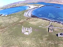
 Kettla Ness seen from the air, including Minn beach | |
| Location | |
| OS grid reference | HU425815 |
| Coordinates | 60°03′N 1°21′W / 60.05°N 1.35°W |
| Physical geography | |
| Island group | Scalloway Islands |
| Area | see West Burra |
| Highest elevation | 48.8 metres (160 ft) |
| Administration | |
| Council area | Shetland Islands |
| Country | Scotland |
| Sovereign state | United Kingdom |
| Demographics | |
| Population | 0[1] |
| References | [2][3] |
Kettla Ness, Kettlaness or just Kettla is a tied island and headland in Shetland.[4] It is connected by the tombolo Minn beach (Banna Minn), to the south end of West Burra, part of the Scalloway Islands.[5][6] The headland itself is conspicuous and circa 160 feet high.[7][8] The island is accessible to walkers via Minn beach and is now uninhabitated.[7] It is principally used for Sheep farming and pasture.[6]
- ^ National Records of Scotland (15 August 2013). "Appendix 2: Population and households on Scotland's Inhabited Islands" (PDF). Statistical Bulletin: 2011 Census: First Results on Population and Household Estimates for Scotland Release 1C (Part Two) (PDF) (Report). SG/2013/126. Retrieved 14 August 2020.
- ^ Haswell-Smith, Hamish (2004). The Scottish Islands. Edinburgh: Canongate. ISBN 978-1-84195-454-7.
- ^ Ordnance Survey. OS Maps Online (Map). 1:25,000. Leisure.
- ^ "Kettla Ness". Gazetteer for Scotland. Retrieved 1 May 2023.
- ^ "Minn Beach". Shetland.org. Retrieved 1 May 2023.
- ^ a b Fitton, Hansom and Rennie (2017). "Dynamic Coast - National Coastal Change Assessment: Cell 11 - Shetland CRW2014/2" (PDF). Dynamic Coast. Retrieved 1 May 2023.
- ^ a b Moore, Hazel; Wilson, Graeme (March 2001), Shetland Coastal Zone Assessment Survey, Historic Scotland and Shetland Amenity Trust, pp. 75–83
- ^ British Islands Pilot: Faroes, Shetlands, and Orkney Islands and north and east coasts of Scotland. US Government Hydrographic Office. 1915. p. 110.
