| Kettle River | |
|---|---|
 Kettle River from railway trestle | |
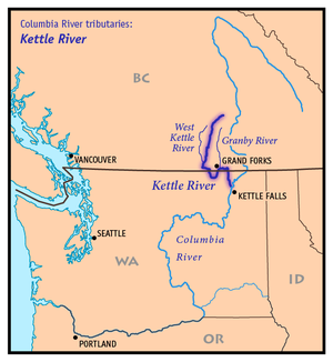
 Map of the Kettle River and its two main tributaries | |
| Location | |
| Country | United States, Canada |
| State | Washington |
| Province | British Columbia |
| City | Grand Forks, BC, Kettle Falls, WA |
| Physical characteristics | |
| Source | Holmes Lake |
| • location | British Columbia, Canada 50°06′55″N 118°18′43″W / 50.11528°N 118.31194°W |
| • coordinates | 50°06′55″N 118°18′43″W / 50.11528°N 118.31194°W |
| Mouth | Columbia River |
• location | Franklin D. Roosevelt Lake, Washington (state) |
• coordinates | 48°40′22″N 118°6′50″W / 48.67278°N 118.11389°W[1] |
• elevation | 1,500 ft (460 m)[2] |
| Length | 175 mi (282 km)[3] |
| Basin size | 4,200 sq mi (11,000 km2)[4] |
| Discharge | |
| • location | Laurier, WA |
| • average | 2,906 cu ft/s (82.3 m3/s) |
| • minimum | 70 cu ft/s (2.0 m3/s) |
| • maximum | 35,000 cu ft/s (990 m3/s) |
| Basin features | |
| Tributaries | |
| • left | Granby River |
| • right | West Kettle River, Rock Creek, Boundary Creek |
The Kettle River is a 281-kilometre (175 mi) tributary of the Columbia River, encompassing a 10,877-square-kilometre (4,200 sq mi) drainage basin, of which 8,228 square kilometres (3,177 sq mi) are in southern British Columbia, Canada and 2,649 square kilometres (1,023 sq mi) in northeastern Washington, US.[4]
- ^ Cite error: The named reference
gniswas invoked but never defined (see the help page). - ^ Google Earth elevation for GNIS mouth coordinates; retrieved May 4, 2007.
- ^ Kettle River Archived 2008-07-16 at the Wayback Machine, The Columbia Gazetteer of North America
- ^ a b Upper Columbia Subbasin Overview Archived 2008-10-02 at the Wayback Machine, p. 29-8; Northwest Power and Conservation Council