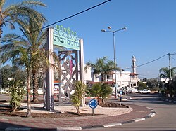
Kfar Kama
כְּפַר כַּמָא كفر كما Кфар Кама | |
|---|---|
Local council (from 1950) | |
| Hebrew transcription(s) | |
| • ISO 259 | Kfar Kamaˀ |
| • Also spelled | Кфар Кама (Adyghe) (official) |
 | |
| Coordinates: 32°43′19″N 35°26′27″E / 32.72194°N 35.44083°E | |
| Grid position | 191/236 PAL |
| Country | |
| District | Northern |
| Founded | 1878 |
| Area | |
| • Total | 8,854 dunams (8.854 km2 or 3.419 sq mi) |
| Population (2022)[1] | |
| • Total | 3,500 |
| • Density | 400/km2 (1,000/sq mi) |
| Name meaning | The village of truffles[2] |
Kfar Kama (Hebrew: כְּפַר כַּמָא, Arabic: كفر كما, Adyghe: Кфар Кама) is a Circassian town located in the Lower Galilee of Israel's northern district, located along road 767, that leads from Kfar Tavor to the Kinneret. It is one of the only two Circassian towns in Israel, the other being Rehaniya. The residents of the town are descended from the Shapsug tribe exilees from Circassia. In 2008, the town had a population of 2,900.[3]
- ^ "Regional Statistics". Israel Central Bureau of Statistics. Retrieved 21 March 2024.
- ^ Palmer, 1881, p. 127
- ^ "Population of Localities Numbering above 2,000 Inhabitants and Other Rural Population" (PDF). Israel Central Bureau of Statistics. 2008-12-31.


