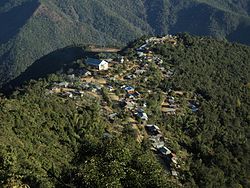
Khamlang | |
|---|---|
Village | |
 | |
| Coordinates: 24°41′45″N 94°15′40″E / 24.69583°N 94.26111°E | |
| Headquarters | Kamjong |
| Area | |
| • Total | 29.8 km2 (11.5 sq mi) |
| Population (2011) | |
| • Total | 485 |
| Time zone | UTC+5:30 (IST) |
| Awunga | Mahaiwung Shanglai |
| Assembly Constituency | Phungyar |
Khamlang village is situated on the southern part of Ukhrul District, Manipur, India. It is inhabited by Khameon (People of Khamlang) a Tangkhul Naga tribe. It is situated 2 km away from headquarter of Sub-Division, Kasom Khullen, 137 km away from district headquarter Ukhrul and 59 km from state capital Imphal, Manipur.[1] [2]
Khamlang is govern by Awunga as the chief of the village and Hangva as his ministers[3]
Khamlang village is a medium size village with a total number of 99 families. It has a population of 485 of which 232 are males while 253 are females as per Population Census 2011. It has lower literacy rate compared to Manipur. In 2011, the literacy rate was 64.96% compared to 76.94% of Manipur, Male literacy stands at 69.04% while female literacy rate was 61.21%. The population of children with age 0-6 is 74 person which makes up 15.26% of total population of village. Average Sex Ratio is 1091 which is higher than Manipur state average of 985. Child Sex Ratio for the Khamlang as per census is 1114, higher than Manipur average of 930.[4]
- ^ "Khamlang Village in Ukhrul South (Ukhrul) Manipur - villageinfo.in". villageinfo.in.
- ^ "Pin Code: LITAN, UKHRUL, MANIPUR, India, Pincode.net.in". pincode.net.in.
- ^ "Poor PMGSY road dashes villagers' hope - Assam Times". www.assamtimes.org.
- ^ "Khamlang Village Population - Ukhrul South - Ukhrul, Manipur". www.census2011.co.in.