This article needs additional citations for verification. (June 2015) |
Khandesh | |
|---|---|
Region | |
 Panoramic view of Purna river near Muktainagar | |
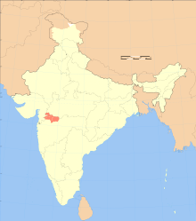
 Blue: Khandesh in Maharashtra Light Blue: Khandesh in Madhya Pradesh (Burhanpur) | |
| Country | India |
| State | Maharashtra and Madhya Pradesh [citation needed] |
| Districts | 1] Jalgaon 2] Dhule 3] Nandurbar 4] Burhanpur |
| Largest City | Jalgaon |
| Languages | Marathi, Khandeshi |
| Elevation | 240 m (790 ft) |
| Demonym | Khandeshi |
| Time zone | UTC+5:30 (IST) |


Khandesh is a geographic region in Maharashtra, India. It was made up of present Jalgaon, Dhule and Nandurbar districts.[1] It also said that Burhanpur District of Madhya Pradesh was also its part.[2][3]
The region have seen many geographical changes, in 1906 its eponymous district was bifurcated to form two new districts that is West Khandesh, East Khandesh district; Dhule and Jalgaon are their headquarters respectively. In 1990s West Khandesh further divided to form a new, district Nandurbar.[1]
The use of the Khandeshi language is prevalent in this region, and the language itself derives its name from the name of the region. This language is sometimes considered as a dialect of Marathi due to its mutual intelligibility with it, and hence has lower numbers in the census due to people opting their language as Marathi instead.[original research?] This region is famous for banana agriculture and is a leading producer of it.[4]
- ^ a b District census handbook Jalgaon (PDF). Mumbai: Directorate of census operations Maharashtra. 2014. Retrieved 9 March 2023.
- ^ Shyam, Radhey (1981). The Kingdom of Khandesh. Delhi: Idarah-i-Adabiyat-i-Delli. p. 21.
- ^ "Welcome to Khandesh!". Khandesh.com. Retrieved 1 August 2010.
- ^ कंत्राटी ग्रामसेवक परीक्षा मार्गदर्शक (in Marathi). Latur. 2021.
{{cite book}}: CS1 maint: location missing publisher (link)