| Khao Sam Roi Yot National Park | |
|---|---|
 Harbor, Bang Pu | |
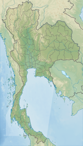
Map of Thailand | |
| Location | Prachuap Khiri Khan Province, Thailand |
| Nearest city | Pranburi |
| Coordinates | 12°10′57″N 99°56′54″E / 12.18250°N 99.94833°E |
| Area | 98 km2 (38 sq mi) |
| Established | 1966 |
| Visitors | 164,735 (in 2019) |
| Governing body | Department of National Parks, Wildlife and Plant Conservation |
| Official name | Khao Sam Roi Yot Wetland |
| Designated | 8 January 2008 |
| Reference no. | 2238[1] |
Khao Sam Roi Yot National Park (Thai: อุทยานแห่งชาติเขาสามร้อยยอด, RTGS: Utthayan Haeng Chat Khao Sam Roi Yot, pronounced [ʔùt.tʰā.jāːn hɛ̀ŋ tɕʰâːt kʰǎw sǎːm rɔ́ːj jɔ̂ːt]) is a marine national park in Kui Buri District, Prachuap Khiri Khan Province, Thailand.[2] It covers 61,300 rai ~ 98 square kilometres (38 sq mi)[3][4] of which 13,050 rai ~ 21 square kilometres (8.1 sq mi) are marine areas. The park was established in 1966, and was the first coastal national park of Thailand. The park includes Thailand's largest freshwater marsh.[5]
- ^ "Khao Sam Roi Yot Wetland". Ramsar Sites Information Service. Retrieved 25 April 2018.
- ^ Cite error: The named reference
DNPwas invoked but never defined (see the help page). - ^ Cite error: The named reference
AREA NPwas invoked but never defined (see the help page). - ^ Svasti, Pichaya (21 June 2018). "Close to Nature". Bangkok Post. Retrieved 21 June 2018.
- ^ Jewett, Katie (6 December 2016). "Fishing-Cat's Cradle". Bangkok Post. Retrieved 6 December 2016.
