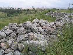
Khirbat Zakariyya
خربة زكريا | |
|---|---|
Village | |
 Remains of Khirbat Zakariyya, 2016 | |
| Etymology: Neby Zakarîya, the prophet Zechariah[1] | |
A series of historical maps of the area around Khirbat Zakariyya (click the buttons) | |
Location within Mandatory Palestine | |
| Coordinates: 31°55′28″N 34°58′23″E / 31.92444°N 34.97306°E | |
| Palestine grid | 147/148 |
| Geopolitical entity | Mandatory Palestine |
| Subdistrict | Ramle |
| Date of depopulation | July 12-13, 1948[2] |
| Area | |
| • Total | 4,538 dunams (4.538 km2 or 1.752 sq mi) |
| Cause(s) of depopulation | Military assault by Yishuv forces |
| Secondary cause | Influence of nearby town's fall |
Khirbat Zakariyya (Arabic: خربة زكريا) was a Palestinian village in the Ramle Subdistrict of Mandatory Palestine. It was depopulated during the 1948 Arab–Israeli War on July 12, 1948, under the second stage of Operation Dani. It was located 9 km (5.6 mi) east of Ramla.
The archaeological site, also known Horbat Zekharya (Hebrew: חורבת זכריה) is today located next to the Technological Park of Modi'in-Maccabim-Re'ut, Israel. It forms part of a cluster of sites located in the Modi'in hills next to ancient roads linking Jerusalem and the coastal plain. This cluster include the site of Khirbat el-Kelkh / Horvat Kelah, and the caves at el-Habs.[5]
In the 19th century it gave the name for an agricultural estate, which formed part of the territory controlled by the Palestinian-Arab Khawaja family of the Yaman tribal group, based in the village of Ni'lin to the east.[6] Kh. Zakariyya was listed in the Village Statistics (1945), prepared by Mandatory Palestine with an of 4,538 dunams,[4] of which about half are used for growing cereals. In July 1948, During Operation Danny, Kh. Zakariyya and other Palestinian-Arab localities in the region were captured and depopulated.
- ^ Palmer, 1881, p. 240
- ^ Morris, 2004, p. xix village #231. Also gives causes of depopulation.
- ^ Department of Statistics, 1945, p. 29
- ^ a b Government of Palestine, Department of Statistics. Village Statistics, April, 1945. Quoted in Hadawi, 1970, p. 67
- ^ Ayelet Hashahar Malka (2012). Christians and Christianity: Corpus of Christian Sites in Samaria and Northern Judea. Jerusalem: Staff Officer of Archaeology. pp. 230–231. ISBN 978-965-406-252-7.
- ^ Roy Marom (2021). "Jindās at Lydda's Entrance: A Cornerstone of the Study of the City's Rural Hinterland (1459 – 1948)". Lod "Diospolis - City of God": Journal of the History, Archaeology and Heritage of Lod (in Hebrew). 7: 22. ISSN 2710-0383.
Note 12: במאה ה-19 ,נחשבה משפחת אל-ח'ואג'ה למנהיגת מחנה הימן בכפרי בני חמאר, ושלטונה התפרס על הכפרים נעלין, אל-מִדְיָא ועל האחוזות זכריא, דיר אבו סלאמה וח'רבת אל-ט'היריה (כיום בתחומי יער בן שמן). [In the 19th century, the al-Khawaja was considered the leading family of the Yaman camp in the Bani Khamar villages, and its rule spread over the villages of Ni'lin, el-Midiya and the estates of Zakariyya, Dayr Abu Salama and Khirbat el-Duheryriya (Today in the bounds of the Ben Shemen Forest).]


