Khirbet Beit Zakariyyah | |
|---|---|
| ar transcription(s) | |
| • Arabic | خربة بيت زكريا |
| • Latin | Khallet Sakarya (unofficial) |
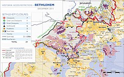
 Area map showing Khallet Sakariya, 2011 | |
| Coordinates: 31°39′47″N 35°07′24″E / 31.66306°N 35.12333°E | |
| Palestine grid | 160/118 |
| State | State of Palestine |
| Governorate | Bethlehem |
| Government | |
| • Type | Village council |
| Elevation | 950 m (3,120 ft) |
| Population (2017)[2] | |
| • Total | 142 |
| Name meaning | Khurbet Beit Skâria; The ruin of Beit Skaria (the ancient Beth Zacharias)[3] |
Khirbet Beit Zakariyyah (variants: Beit Iskâria, Khirbet Zakariah, Beit Skâria) is a small Palestinian village southwest of Bethlehem in the West Bank, perched on a hill that rises about 995 metres (3,264 ft) above sea level. Administratively, it is associated with the village of Artas under the Bethlehem Governorate. It is also located in between the Israeli settlements of Alon Shevut and Rosh Tzurim, both of which were built on land confiscated from the village. The village had a population of 142 in 2017.[2]
- ^ Beit Sakariya Village Profile, ARIJ, p. 4
- ^ a b Preliminary Results of the Population, Housing and Establishments Census, 2017 (PDF). Palestinian Central Bureau of Statistics (PCBS) (Report). State of Palestine. February 2018. pp. 64–82. Retrieved 2023-10-24.
- ^ Palmer, 1881, p. 302

