Khlong San
คลองสาน | |
|---|---|
 Skyscrapers on the Chao Phraya River, Khlong San | |
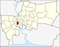
 Khet location in Bangkok | |
| Coordinates: 13°43′49″N 100°30′35″E / 13.73028°N 100.50972°E | |
| Country | Thailand |
| Province | Bangkok |
| Seat | Khlong San |
| Khwaeng | 4 |
| Area | |
| • Total | 6.051 km2 (2.336 sq mi) |
| Population (2017) | |
| • Total | 73,263[1] |
| • Density | 12,107.59/km2 (31,358.5/sq mi) |
| Time zone | UTC+7 (ICT) |
| Postal code | 10600 |
| Geocode | 1018 |
Khlong San (Thai: คลองสาน, pronounced [kʰlɔ̄ːŋ sǎːn]) is one of the 50 districts (khet) of Bangkok, Thailand. On the west bank of Chao Phraya River, its neighboring districts across the river are (from north clockwise) Phra Nakhon, Samphanthawong, Bang Rak, Sathon, and Bang Kho Laem. On the west side of the river, the only land neighbor is Thon Buri district.
- ^ "Population and House Report for Year 2017". Department of Provincial Administration, Ministry of Internal Affairs. Retrieved 2018-04-01. (Search page)