This article needs additional citations for verification. (April 2021) |
Khlong Toei
คลองเตย | |
|---|---|
 View of Khlong Toei from Asok intersection toward Nana | |
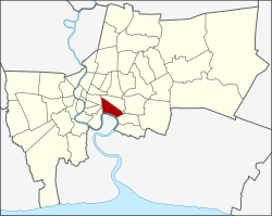
 Khet location in Bangkok | |
| Coordinates: 13°42′29″N 100°35′2″E / 13.70806°N 100.58389°E | |
| Country | Thailand |
| Province | Bangkok |
| Seat | Khlong Toei |
| Khwaeng | 3 |
| Khet established | 9 November 1989 |
| Area | |
• Total | 13.0 km2 (5.0 sq mi) |
| Population (2017) | |
• Total | 102,945[1] |
| • Density | 7,918.84/km2 (20,509.7/sq mi) |
| Time zone | UTC+7 (ICT) |
| Postal code | 10110 except parts of Phra Khanong: 10260 |
| Geocode | 1033 |
Khlong Toei (also Klong Toey, Thai: คลองเตย, pronounced [kʰlɔ̄ːŋ tɤ̄ːj]) is a district in central Bangkok, long known for its slum. It is bordered by the Chao Phraya River and contains major port facilities. It is also the site of a major market, the Khlong Toei Market.
Neighboring districts are (clockwise from the north): Watthana, Phra Khanong, Phra Pradaeng district of Samut Prakan province (across the Chao Phraya), Yan Nawa, Sathon, and Pathum Wan.
- ^ "Population and House Report for Year 2017 (see page 2 for data of this district)". Department of Provincial Administration, Ministry of Internal Affairs. Retrieved 2018-04-01. (Search page)