| Khunjerab Pass | |
|---|---|
 Khunjerab Pass | |
| Elevation | 4,693 m (15,397 ft) |
| Traversed by | |
| Location | Hunza-15801, Pakistan - administered Gilgit–Baltistan / Xinjiang, China |
| Range | Karakoram Range |
| Coordinates | 36°51′00″N 75°25′42″E / 36.85°N 75.4283°E |
 | |
| Khunjerab Pass | |||||||
|---|---|---|---|---|---|---|---|
| Chinese name | |||||||
| Traditional Chinese | 紅其拉甫山口 | ||||||
| Simplified Chinese | 红其拉甫山口 | ||||||
| |||||||
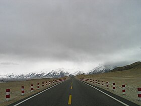
Khunjerab Pass (Chinese: 红其拉甫口岸; Urdu: درہ خنجراب ; Uyghur: قونجىراپ ئېغىزى) is a mountain pass in northern Pakistan that lies at an elevation of 4,693 metres (15,397 ft) above sea level. It is located in the Karakoram and holds a significant strategic position on the northern border of Pakistan, specifically in the Gilgit-Baltistan's Hunza and Nagar Districts. Additionally, it is positioned on the southwestern border of China, within the Xinjiang region.
Near Khunjerab Pass, there is another pass known as Mutsjliga Pass, which stands at an elevation of 5,314 metres (17,434 ft) and is located at approximately 36°58′25″N 75°17′50″E / 36.97374°N 75.2973°E.

