This article needs additional citations for verification. (March 2010) |
Kilanerin
Irish: Coill an Iarainn | |
|---|---|
Village | |
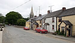
 Houses and church steeple in Kilanerin | |
| Coordinates: 52°43′48″N 6°17′06″W / 52.730°N 6.285°W | |
| Country | Ireland |
| Province | Leinster |
| County | County Wexford |
| Elevation | 48 m (157 ft) |
| Population | 244 |
| Time zone | UTC+0 (WET) |
| • Summer (DST) | UTC-1 (IST (WEST)) |
Kilanerin or Killinierin (Irish: Coill an Iarainn, meaning 'forest of iron')[2] is a village in north County Wexford, Ireland, 4 kilometres west of the N11 road, near the village of Inch and approximately 12 kilometres from the town of Gorey.
It lies in the foothills of Croghan Mountain, the site of a once-famous gold rush.
- ^ "Sapmap Area - Settlements - Killinierin". Census 2016. Central Statistics Office. April 2016. Retrieved 25 March 2020.
- ^ "Coill an Iarainn / Killinierin". logainm.ie. Placenames Database of Ireland. Retrieved 25 March 2020.
