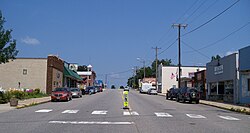
Kimball | |
|---|---|
 Downtown Kimball | |
 Location of Kimball within Stearns County, Minnesota | |
| Coordinates: 45°18′52″N 94°18′03″W / 45.31444°N 94.30083°W | |
| Country | United States |
| State | Minnesota |
| County | Stearns |
| Area | |
| • Total | 1.51 sq mi (3.92 km2) |
| • Land | 1.51 sq mi (3.92 km2) |
| • Water | 0.00 sq mi (0.00 km2) |
| Elevation | 1,165 ft (355 m) |
| Population (2020) | |
| • Total | 799 |
| • Density | 528.44/sq mi (204.05/km2) |
| Time zone | UTC-6 (CST) |
| • Summer (DST) | UTC-5 (CDT) |
| ZIP code | 55353 |
| Area code | 320 |
| FIPS code | 27-33164[3] |
| GNIS feature ID | 2395529[2] |
| Website | ci.kimball.mn.us |
Kimball (/ˈkɪmbəl/ KIM-bəl)[4] is a city in Stearns County, Minnesota, United States. The population was 799 at the 2020 census.[5] It is part of the St. Cloud Metropolitan Statistical Area.
- ^ "2020 U.S. Gazetteer Files". United States Census Bureau. Retrieved July 24, 2022.
- ^ a b U.S. Geological Survey Geographic Names Information System: Kimball, Minnesota
- ^ "U.S. Census website". United States Census Bureau. Retrieved January 31, 2008.
- ^ "Minnesota Pronunciation Guide". Associated Press. Archived from the original on July 22, 2011. Retrieved July 4, 2011.
- ^ "Explore Census Data". United States Census Bureau. Retrieved June 16, 2022.