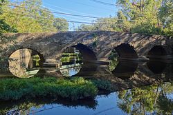
King's Highway Historic District | |
 The Kingston Bridge built 1798 to replace one destroyed by George Washington's troops to prevent British pursuit after the Battle of Princeton | |
| Location | US 206 from mile marker 48.3 to 53.9 and Route 27 from mile marker 0.0 to 4.1 |
|---|---|
| Coordinates | 40°20′53.8″N 74°39′52.0″W / 40.348278°N 74.664444°W |
| Area | 81 acres (33 ha) |
| Built | 1660–1950 |
| Architect | Multiple |
| NRHP reference No. | 00001493 |
| NJRHP No. | 353[1] |
| Significant dates | |
| Added to NRHP | December 21, 2000 |
| Designated NJRHP | October 23, 2000 |
The King's Highway Historic District covers the portions of US 206 and Route 27 in New Jersey that connect Lawrenceville (in Lawrence) with Kingston (in Franklin Township / South Brunswick, New Jersey) through Princeton. This historic roadway dates to colonial times and was a portion of the King's Highway that was laid out by order of Charles II of England to connect Boston with Charleston. It is lined with many institutions and sites that have played an important role in the History of the United States, including Princeton University and the Princeton Theological Seminary.
Along the road can be found five National Historic Landmarks: the Lawrenceville School, Morven, Maclean House, Nassau Hall, and the Joseph Henry House. The highway also runs through eight historic districts, from west to east, Lawrence Township Historic District, Princeton Battlefield / Stony Brook Village Historic District, Princeton Historic District, Jugtown Historic District, Kingston Mill Historic District, Lake Carnegie Historic District, Delaware and Raritan Canal Historic District and the Kingston Village Historic District. The governor's mansion of New Jersey, Drumthwacket, independently listed on the National Register of Historic Places, is found on the road in the western part of Princeton. The district was added to the National Register of Historic Places on December 21, 2000 for its significance in commerce, exploration, settlement, military, politics, government and transportation from 1660 to 1950. The highway itself is the only contributing structure.[2]
- ^ "New Jersey and National Registers of Historic Places — Mercer County" (PDF). New Jersey Department of Environmental Protection — Historic Preservation Office. April 5, 2013. p. 8. Archived from the original (PDF) on May 16, 2013. Retrieved June 4, 2013.
- ^ Greiff, Constance. "National Register of Historic Places Inventory/Nomination: King's Highway Historic District". National Register of Historic Places. National Park Service.With 63 accompanying pictures


