Kings County, California | |
|---|---|
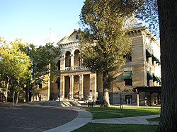
| County of Kings | |
 | |
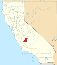
 Interactive map of Kings County | |
 Location in the state of California | |
| Coordinates: 36°04′N 119°49′W / 36.07°N 119.81°W | |
| Country | United States |
| State | California |
| Region | San Joaquin Valley |
| Metropolitan area | Hanford-Corcoran |
| Established | March 22, 1893[1] |
| Named for | Kings River |
| County seat | Hanford |
| Largest city | Hanford (population) Avenal (area) |
| Incorporated cities | 4 |
| Government | |
| • Type | Council–CAO |
| • Body | Board of Supervisors |
| • Chair | Richard Fagundes |
| • Vice Chair | Doug Verboon |
| • Board of Supervisors[2] | Supervisors
|
| • County Administrative Officer | Edward Hill |
| Area | |
| • Total | 1,392 sq mi (3,610 km2) |
| • Land | 1,389 sq mi (3,600 km2) |
| • Water | 2.1 sq mi (5 km2) |
| Highest elevation | 3,476 ft (1,059 m) |
| Population (2020) | |
| • Total | 152,486 |
| • Density | 110/sq mi (42/km2) |
| GDP | |
| • Total | $8.146 billion (2022) |
| Time zone | UTC−8 (Pacific Time Zone) |
| • Summer (DST) | UTC−7 (Pacific Daylight Time) |
| Area code | 559 |
| FIPS code | 06-031 |
| GNIS feature ID | 277280 |
| Congressional districts | 20th, 22nd |
| Website | countyofkings.com |
Kings County is a county located in the U.S. state of California. The population was 152,486 at the 2020 census.[5] The county seat is Hanford.[6]
Kings County comprises the Hanford-Corcoran, CA metropolitan statistical area, which is also included in the Visalia-Porterville-Hanford, CA combined statistical area. It is in the San Joaquin Valley, a rich agricultural region.
- ^ "Kings County". Geographic Names Information System. United States Geological Survey, United States Department of the Interior.
- ^ "Board of Supervisors | Kings County".
- ^ Table Mountain
- ^ "Gross Domestic Product: All Industries in Kings County, CA". Federal Reserve Economic Data. Federal Reserve Bank of St. Louis.
- ^ "Kings County, California". United States Census Bureau. Retrieved January 30, 2022.
- ^ "Find a County". National Association of Counties. Archived from the original on May 31, 2011. Retrieved June 7, 2011.

