| Kings Meadows Launceston, Tasmania | |||||||||||||||
|---|---|---|---|---|---|---|---|---|---|---|---|---|---|---|---|
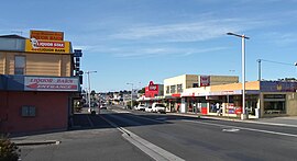
 View south down Hobart Road through Kings Meadows | |||||||||||||||
 | |||||||||||||||
| Coordinates | 41°28′14″S 147°09′47″E / 41.4706°S 147.1631°E | ||||||||||||||
| Population | 3,670 (2016 census)[1] | ||||||||||||||
| Postcode(s) | 7249 | ||||||||||||||
| Location | 4 km (2 mi) S of Launceston, Tasmania | ||||||||||||||
| LGA(s) | Launceston | ||||||||||||||
| Region | Launceston | ||||||||||||||
| State electorate(s) | Bass | ||||||||||||||
| Federal division(s) | Bass | ||||||||||||||
| |||||||||||||||
Kings Meadows is a residential locality in the local government area (LGA) of Launceston in the Launceston LGA region of Tasmania. The locality is about 5 kilometres (3.1 mi) south of the town of Launceston. The 2016 census has a population of 3670 for the state suburb of Kings Meadows.[1] It is a suburb in the south of Launceston. Kings Meadows is located in the floor of a shallow valley, roughly 70m above sea level, which drains NE towards the small suburb of Punchbowl. Main access to the suburb from the CBD is from Hobart Road via the minor suburb of South Launceston. Kings Meadows High School is located in this suburb.
- ^ a b "2016 Census Quick Stats Kings Meadows (Tas.)". quickstats.censusdata.abs.gov.au. Australian Bureau of Statistics. 23 October 2017. Retrieved 13 September 2020.
