| Kings River Spanish: Río de los Santos Reyes | |
|---|---|
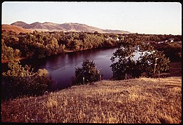
 The Kings River in the San Joaquin Valley about 10 miles (16 km) below Pine Flat Dam | |
 Map showing the Kings River and its tributaries. The canal system fed by Kings River is shown in light blue. | |
| Native name | Wimmel-che (Yokuts)[1] |
| Location | |
| Country | United States |
| State | California |
| Region | Kings Canyon National Park, Fresno County, California, Kings County, California |
| Physical characteristics | |
| Source | Confluence of Middle and South Forks |
| • location | Sierra Nevada |
| • coordinates | 36°50′17″N 118°52′29″W / 36.83806°N 118.87472°W[1] |
| • elevation | 2,257 ft (688 m) |
| Mouth | Tulare Lakebed |
• location | San Joaquin Valley |
• coordinates | 36°03′00″N 119°49′28″W / 36.05000°N 119.82444°W[1] |
• elevation | 184 ft (56 m)[1] |
| Length | 132.9 mi (213.9 km)[2] |
| Basin size | 1,544 sq mi (4,000 km2)[2] |
| Discharge | |
| • location | Piedra, California[3] |
| • average | 2,287 cu ft/s (64.8 m3/s)[3] |
| • minimum | 20.1 cu ft/s (0.57 m3/s) |
| • maximum | 91,000 cu ft/s (2,600 m3/s)[4] |
| Basin features | |
| Tributaries | |
| • left | South Fork Kings River, Mill Creek |
| • right | Middle Fork Kings River, North Fork Kings River |
| Type | Wild |
| Designated | November 3, 1987 |
The Kings River (Spanish: Río de los Santos Reyes), is a 132.9-mile (213.9 km)[2] river draining the Sierra Nevada mountain range in central California in the United States. Its headwaters originate along the Sierra Crest in and around Kings Canyon National Park and form the eponymous Kings Canyon, one of the deepest river gorges in North America. The river is impounded in Pine Flat Lake before flowing into the San Joaquin Valley (the southern half of the Central Valley) southeast of Fresno. With its upper and middle course in Fresno County, the Kings River diverges into multiple branches in Kings County, with some water flowing south to the old Tulare Lake bed and the rest flowing north to the San Joaquin River. However, most of the water is consumed for irrigation well upstream of either point.
Inhabited for thousands of years by the Yokuts and other native groups, the Kings River basin once fed a vast network of seasonal wetlands around Tulare Lake that supported millions of waterfowl, fish, and game animals, in turn providing sustenance for indigenous peoples. Tulare Lake was once the largest freshwater lake in the western U.S., at the middle of an endorheic basin also fed by the Kaweah, Tule and Kern Rivers. The river was named by Gabriel Moraga, the commander of a Spanish military expedition in 1806, but it was not until California became a U.S. state in 1850 that many Europeans arrived and settled along the Kings River, driving out the area's original inhabitants. Logging and livestock grazing inflicted significant environmental damage on the upper parts of the river system, before the federal government moved to establish national parks and preserves there.
The Kings has a long history of water development, going back to the mid-19th century when farmers made their first attempts to irrigate with Kings River water. In the early 1900s Tulare Lake and its surrounding wetlands were diked, drained and reclaimed for agriculture; the construction of Pine Flat Dam in the 1950s tamed the river's seasonal floods. The battle for control over Kings River water produced extended conflicts, including a set of dams proposed in what would become Kings Canyon National Park. Today, the river irrigates about 1.1 million acres (4,500 km2) of some of the most productive farmland in the country, and is also used extensively for hydropower generation, and water-based and backcountry recreation.
- ^ a b c d "Kings River". Geographic Names Information System. United States Geological Survey, United States Department of the Interior. 1981-01-19. Retrieved 2010-09-14.
- ^ a b c Cite error: The named reference
NHDwas invoked but never defined (see the help page). - ^ a b "USGS Gage #11222000 on the Kings River at Piedra, CA (Monthly Streamflow)". National Water Information System. United States Geological Survey. 1896–1959. Retrieved 2010-09-14.
- ^ "USGS Gage #11222000 on the Kings River at Piedra, CA (Peak Streamflow)". National Water Information System. United States Geological Survey. 1896–1959. Retrieved 2010-09-14.
